
On Monday 20th January Guildford Borough Council will start to send out our renewal reminders for the garden waste service. The price has increased from £38 to £41. This increase is because GBC’s costs have increased as they now pay for the full cost of the disposal of garden waste where this was covered by Surrey County Council in previous years.
The renewal process is starting early this year at the request of GBC’s finance team to ensure that they have the capacity to switch systems at the start of April. The first notifications will start going out from Monday and will continue through to the following week when the letters will go into the post. Direct debit customers will be notified in February.
There has been a slight dip in renewals combined with an increase in residents attempting to present a container without signing up to the service. GBC will be writing to all properties that have not renewed the service in the last two years to encourage them to renew this year.
1. Introduction
We are all familiar with boundaries because we see them every day. Our own properties will probably have some kind of boundary structure that separates it from neighbouring properties. Some structures appear natural, living things like hedges and tree lines. Others are obviously man-made such as walls, timber fences and ditches.
2. Definition of a boundary
The word ‘boundary’ has no special meaning in law. There are 2 senses in which it can be used: legal boundary and physical boundary.
2.1 Legal boundary
An imaginary or invisible line dividing one person’s property from that of another. It is an exact line having no thickness or width and is rarely identified with any precision either on the ground or in conveyances or transfers and is not shown on Ordnance Survey mapping. Ultimately the exact position of a boundary, if disputed, can be determined only by the court or the Land Registration division of the Property Chamber, First-tier Tribunal.
2.2 Physical boundary
A physical feature that we can see such as a fence, wall or a hedge, which may, coincidentally, also follow the line of a legal boundary. The legal boundary may run within the physical boundary structure but it might just as easily run along one particular side of the structure, or include all or any part of an adjoining roadway or stream. Living boundary structures such as hedges can be prone to a certain degree of movement: for example, if a hedge is left untended it might take root where it touches the ground and become very wide, making its original line hard to discern. So even if it is clear that the legal boundary ran along the hedge, identifying this boundary on the ground may become very difficult.
3. Difficulties in showing the precise position of physical boundaries on plans
Ordnance Survey translates the landscape into mapping we use today and have used for many decades. A line shown on the Ordnance Survey map indicates that a feature existed in that position, subject to certain limitations at the time of the survey. See practice guide 40: supplement 1 - the basis of HM Land Registry plans for more information.
Whilst the precise position of the physical features, which may give an indication of the occupied extent or the general position of a legal boundary, may be determined by inspection on the ground, the extent to which their precise position may be recorded on a plan will largely depend on the accuracy of the survey on which such a plan is based. Even the most detailed surveys with the most modern and highly accurate survey instruments take place within certain defined tolerances and large-scale Ordnance Survey mapping is no exception.
4. Identifying the position of the legal boundary
Case law establishes that the position of the legal boundary will depend on the terms of the relevant pre-registration conveyance or the transfer as a whole, including, of course, the plan. If the plan is insufficiently clear for the reasonable layperson to determine the position of the boundary, the court can refer to extrinsic evidence and in particular to the physical features on the ground at the time.
This is the case whether or not the plan is ‘for the purposes of identification only’. The question for the court is: what would the reasonable layperson think they were buying? Evidence of the parties’ subjective intentions, beliefs and assumptions is irrelevant. See, for example, Cameron v Boggiano [2012] EWCA Civ 157.
5. General boundaries
Given the difficulties referred to above in establishing the position of the legal boundary, the great majority of registered titles show only the ’general boundaries’, under section 60(1) of the Land Registration Act 2002.
We will complete a first registration without making detailed enquiries as to the precise location of the legal boundaries. Practice guide 40: supplement 5 - title plan for a definition will reflect what we conclude to be a reasonable interpretation of the land in the pre-registration deeds in relation to the detail on Ordnance Survey mapping, taking into account any areas of land that the pre-registration deeds show to have been sold off and any existing adjoining registrations.
Unlike the tolerances applied to Ordnance Survey mapping, there is no standard tolerance, measurement or ratio that can be attributed to the relationship between the position of the general boundary mapped on an HM Land Registry title plan and the position of the legal boundary. See practice guide 40: supplement 1 - the basis of HM Land Registry plans for more information.
Case law makes clear that there is no limit to the quantity of land that can fall within the scope of the general boundaries rule: see, for example, Drake v Fripp [2011] EWCA Civ 1279.
6. Fixed boundaries
This procedure has been superseded by the determined boundaries provisions referred to in practice guide 40: supplement 4 - boundary agreements and determined boundaries. It allowed the precise identification and registration of the position of part or the whole of the title boundaries. Fixing a boundary was a very expensive process and only a handful of fixed boundary titles were successfully registered.
7. Boundary agreements and determined boundaries
However effective registration with general boundaries is for the majority of titles, there are occasions where an owner might require something more precise. There are 2 ways to achieve this:
using a boundary agreement
lodging a determined boundary application
The first option always requires the agreement of adjoining owners and the second almost invariably will also require this. For further information see practice guide 40: supplement 4 - boundary agreements and determined boundaries.
8. Ownership and/or maintenance of boundaries
There are various notions that the way a wall or fence is constructed indicates ownership, for example that the posts and arris rails of a fence are on the owner’s side. There is, however, no legal foundation for such beliefs. Deeds may contain covenants to maintain a wall or fence but on their own, such covenants do not confer ownership. Where the ownership or responsibility for maintenance of a boundary cannot be determined, that boundary feature is generally best regarded as a party boundary. Any alterations or replacement of the boundary should only be done with the agreement of the adjoining owners.
The register will only show information concerning the ownership and/or maintenance of boundary features when this information is specifically referred to in the deeds lodged for registration. The most common marking on deed plans that relates to boundaries are ‘T’ marks. An entry referring to a ‘T’ mark is normally a statement concerning the ownership of a boundary structure or the liability to maintain and repair it.
If the ‘T’ marks are expressly referred to in the deed lodged for registration and the text of the provision(s) is set out verbatim in the register, then we will:
reproduce them on the title plan and refer to them in the register, or
describe the boundaries affected by ‘T’ marks verbally in the register, for example “The ‘T’ mark referred to [in paragraph/clause…] affects the [north western] boundary of the land in this title”, or
make a note to the said register entry that a copy of the plan to the deed is filed
‘T’ marks on deed plans which are not referred to in the text of a deed have no special force or meaning in law and unless an applicant specifically requests that the ‘T’ marks be shown on the title plan, we will normally ignore them.
9. Party Wall etc Act 1996
The purpose of this Act is to regulate the manner in which works to party walls and other works adjacent to boundaries are carried out. In general terms the Act does not affect ownership of land although it does provide that the owner who has carried out works remains the owner of those works until the neighbour pays a share of the costs. We cannot offer advice about the Act, this should be sought from an appropriate professional adviser, for example a solicitor, licensed conveyancer or surveyor.
10. Accretion and diluvion: non-tidal rivers and streams
The doctrine of accretion and diluvion recognises the fact that where land is bounded by water, the forces of nature are likely to cause changes in the boundary between the land and the water. We would expect these changes to be gradual and imperceptible. As the watercourse changes naturally and progressively with time, so the land boundary follows it. There may be some gain, there may be some loss. The law accepts this and considers it to be fair.
If a violent flood wrenches the watercourse suddenly but permanently into a different direction so that a substantial and recognisable change in the boundary has taken place, then the doctrine of accretion does not apply. Neither does it apply if the changes are man-made. Land is conveyed subject to and with the benefit of any additions or subtractions (within the limits of the doctrine) that may have taken place over the years.
The boundary between registered titles abutting a natural non-tidal river or stream changes if the course of the stream changes naturally over a period of time. The fact that a title plan may show the boundary in a particular position does not affect the loss and gain of land resulting from the operation of accretion and diluvion (section 61(1), Land Registration Act 2002).
An agreement between adjoining owners about the operation of accretion and diluvion must be registered to have any effect (section 61(2) of the Land Registration Act 2002). The application must be accompanied by the consent of the proprietors of both titles and any registered charges (unless they are party to the agreement) (rule 123 of the Land Registration Rules 2003).
11. Legal presumptions
Documents of title rarely contain sufficient descriptions to enable one to establish the precise position of a boundary. In such cases legal presumptions relating to certain types of boundary feature may be helpful.
As registration with general boundaries leaves the exact line of the boundary undetermined, the effect of a legal presumption may be carried forward into a registered title. Other available evidence, such as a declaration as to the position or ownership of a boundary, may rebut such a presumption.
Where the boundary is a general boundary, we still try to show the land and its boundaries as accurately as possible. So if a person has grounds for believing that a legal presumption operates and that the red edging on a title plan ought to include additional land as a result, they may apply for the register to be altered to show the red edging on the plan in a more accurate position. The boundary will however remain a general boundary. The application should be made by way of form AP1 (even if the land to be included within the red edging of the title plan does not fall within the red edging of the title plan to another registered title, and so may appear to be unregistered).
Legal presumptions cannot apply when the boundary is determined under section 60 of the Land Registration Act 2002. Because this establishes the exact line of the legal boundary, there is no leeway to argue that the boundary is in any other position or that the title includes any other land.
11.1 Roadways
There are 2 presumptions relating to the ownership of the soil of a roadway (where a road or path is a highway maintainable at the public expense, the surface vests in the highway authority: section 263 of the Highways Act 1980).
The first is that the owner of land abutting on a road is also the owner of the adjoining section of the road up to the middle line (ad medium filum).
The second is that where a conveyance or transfer of land abutting on a road is made by someone owning land on one side of it only, then if they can be proved or are presumed, to own also the road up to the middle line, this half of the roadway is included in the conveyance or transfer.
Both of these presumptions may readily be rebutted.
11.2 Hedge and ditch
Where 2 properties are divided by a hedge or bank and an artificial ditch, the boundary is presumed to run along the edge of the ditch furthest from the hedge or bank. This is based on the principle that an owner, standing on his boundary looking inward, dug his drainage ditch within his boundary, threw up the soil on his home side, and then planted a hedge on the mound. This presumption only applies to man-made ditches and does not apply if it can be shown that the ditch is natural or if it can be established that the boundary feature was made while the lands on both sides were in common ownership.
11.3 Non-tidal rivers and streams
Where properties are separated by a natural non-tidal river or a stream, the presumption is that the boundary follows the centre line of the water (ad medium filum aquae) so that each owner has half of the bed.
If the course of the stream gradually changes over a period of time, the position of the boundary will change accordingly. See Accretion and diluvion: non-tidal rivers and streams. Changes as a result of human agency do not, however, lead to an alteration in the position of the boundary. Where there is a sudden, but permanent change in the course of the stream, whether or not it is due to natural causes, the boundary will remain along the centre line of the former bed.
11.4 Lakes
The bed of a lake belongs to the owner of the surrounding land if the lake is entirely within the boundaries of a single ownership. Otherwise there does not appear to be any presumption.
11.5 Foreshore and tidal rivers
In the absence of contrary evidence, the boundary of land adjoining the sea lies at the top of the foreshore (the land lying between the high and low water-marks of a mean average tide between spring and neap tides).
In the absence of evidence to the contrary foreshore is owned by the Crown. This assumption also applies to land bordering on tidal rivers and sea inlets. The boundary may move gradually, as the line of the high water mark moves naturally over the years. However, in the case of a sudden substantial accretion of land or conversely an encroachment by the sea, the ownership of the area of land affected will not change.
As in the case of non-tidal rivers and streams (see Accretion and diluvion: non-tidal rivers and streams), a change as a result of human intervention will not alter the position of the boundary.
11.6 Projections (such as eaves or foundations)
Plans attached to pre-registration deeds generally show the boundaries of a property at ground level only but the foundations and eaves may extend beyond the defined boundary line. In such a case, the property includes these projections (but not the air space between them), unless there is evidence to the contrary.
11.7 Airspace and subsoil
If the terms of pre-registration deeds do not do so, then in the absence of agreement, only a court can determine the precise horizontal boundary between a flat or maisonette on one level and the flat or maisonette above or below it. There are presumptions the court may consider and it will also look at the provisions in the relevant deed, such as repairing covenants in a lease.
Where the division is vertical, there is a presumption that the land includes both the airspace above (to such height as is necessary for the ordinary use and enjoyment of the land) and everything under the soil, subject to exclusions such as coal.
12. Things to remember
We only provide factual information and impartial advice about our procedures. Read more about the advice we give.
CANCELLED
GUILDFORD ENVIRONMENTAL FORUM
Monday 16th March 2020 - 19.45 at The Shackleford Centre, Shackleford Road, Shackleford, GU8 6AE
DAVID ATTENBOROUGH says that climate change is humanity’s greatest threat in thousands of years, that could lead to the extinction of much of the natural world. Local communities need to help counter this threat.
HOW SHOULD GUILDFORD REACT TO THE CLIMATE EMERGENCY? Guildford Environmental Forum (GEF) is offering a talk and discussion on this vital subject to all parish councils and Residents’ Associations in the Borough. Henrietta Stock, who trained with Al Gore in the US, has now helped to prepare our short presentation, which we trust will spark plenty of audience discussion. Members of GEF’s Climate Crisis Group will attend the talks and answer questions.
We look forward to seeing you.
The Parish Council is working together with Surrey County Councillor Matt Furniss to establish a village speed watch group. We ideally need enough people to team up to cover various locations around the villages over sustained periods for best effect.
Training will be given to volunteers to check speed and record information that can be used by the Police to contact repeat offenders. We already have several people willing to take part but need more to make the teams effective.
If you’d like to help with identifying those drivers who speed through our area then please get in touch with our clerk Margaret at clerk@saspc.info to register your interest.
Each year the Pilgrim Marathon event is held at The Sands Recreation ground and is organised by the Rotary Club of Farnham Weyside. The Parish Council gives permission for the charitable event to take place here and we are proud to be associated with it. The Pilgrim Marathon is their single largest money raising event of the year and 2019’s 10th Anniversary race raised a record breaking £19,828.58 net profit.
In recognition of the support given by the Parish Council to the Rotary Club of Farnham Weyside, the organising committee are to donate £200 to the parish funds at a presentation evening on 18th February 2020.
This year’s event will take place on 13th September.
We only have a few watercourses in the parish. If you know you are, or after reading this guidance you realise you are a riparian owner please can you check the watercourse/s you are responsible for and maintain them as required.
The following information has been provided by Surrey County Council (Riparian Owners FAQs)
Riparian Ownership; Frequently Asked Questions
What is a watercourse?
A watercourse is…
every river, stream, brook, ditch, drain, culvert, pipe and any other passage through which water may flow. A watercourse can be either natural or man-made. Watercourses drain the land, prevent flooding and assist in supporting flora and fauna. Historically, watercourses have taken water runoff from buildings and roads, as well as fields and parks. In the process of development many have been culverted (piped) or changed in other ways.
In normal conditions a watercourse may be a dry channel in the ground; in heavy storm conditions it may become a raging torrent. Watercourses do not include public sewers but it could be in a pipe under the ground.
A Main River is…
usually a larger stream or river. However, locally important smaller watercourses can be designated as Main Rivers. The Environment Agency has authority, powers, rights and responsibilities for managing Main Rivers in England and Wales; a ‘Flood Map’ detailing their locations can be found on the Environment Agency website at www.environment-agency.gov.uk.
An Ordinary Watercourse is…
any other river, stream, ditch and culvert not defined as Main River. The responsibility for maintenance of ordinary watercourses lies with anyone who owns land or property adjacent to a watercourse. This is known as Riparian Ownership
It may not always be possible to see a clear physical difference between watercourses designated as either Main River or Ordinary Watercourse.
What is a Riparian Owner?
A riparian owner is the person, or people, with watercourses on, next to or under their property. Riparian owners have the responsibility for maintenance of these watercourses. Riparian responsibilities usually lie with the person who owns the land or property but may be the tenant depending upon the agreement in place.
How do I know if I am a riparian owner?
Unless otherwise shown on the Title Deeds, all of the land owners in this picture would normally be riparian owners up to the middle of the watercourse:

House A is responsible for the all of the watercourse running through their garden
House B is responsible for the watercourse behind the fence at the bottom of their garden
House C is responsible for the watercourse behind the fence AND the pond
House D is responsible for the culverted (piped) watercourse buried in the ditch in front of their land AND the underground pipe which runs beneath their property to the pond House E is responsible for the open ditch in front of their house AND the piped section under their access bridge
House F is responsible for the watercourse at the end of their garden behind their hedge
Landowner G is responsible for both the watercourses running along the edges of their land AND the pond
How much of the watercourse am I responsible for?
If both banks of a watercourse runs through (or under) your land, you are fully responsible for its maintenance. If it runs adjacent to your land (even does not fall within your property boundary as set out by your Title Deeds e.g if it is the other side of a boundary fence) then you are likely to be responsible for the maintenance of the watercourse bank on your side, to halfway across the bottom of the watercourse.
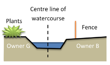
Using the example properties above, Owners G and B would each have responsibility for the maintenance of their side up to the middle of the watercourse. So unless the landowners’ Title Deeds show otherwise, it is presumed that each party owns to the centre line of the watercourse.
Depending upon the specific situation regarding land ownership, the responsibilities may vary and local advice should be sought if in doubt.
What are my responsibilities as a riparian owner?
The riparian responsibilities under law are:
To pass on water flow without obstruction, pollution or diversion that would affect the rights of others.
To maintain the banks and bed of the watercourse (including any trees and shrubs growing on the banks) and any flood defences that exist on it.
To maintain any approved structures on their stretch of the watercourse and keep them free of debris. These may include trash screens, culverts, weirs and mill gates.
Riparian Owners must not build new structures (for example a culvert, bridge or board walk) that encroach upon the watercourse, or alter the flow of water or prevent the free passage of fish without first obtaining permission from the Lead Local Flood Authority (Surrey County Council) or Environment Agency.
Do I have any rights as a riparian landowner?
Yes! Riparian Owner rights are:
To receive a flow of water in its natural state, without undue interference in its quantity or quality
To protect their property against flooding from the watercourse and to prevent erosion of the watercourse banks or any nearby structures
A Riparian Owner usually has the right to fish in the watercourse, provided legal methods are used. A rod licence will usually be required from the Environment Agency.
A Riparian Owner can abstract a maximum of 20 cubic metres of water per day for the domestic purposes of their own household or for agricultural use (excluding spray irrigation) without a license. Most other types of abstraction will require a license from the Environment Agency. If the water is to be used for drinking the abstraction must be registered with the District or Borough Council.
I’m not sure which land I own. How can I find out?
If you are not sure where exactly the border of your land is there are various ways you can find out; from having a chat with your neighbours and checking your property deeds or contacting the Land Registry. Be aware the title deeds for the property may not show the watercourse within your property boundary.
What if I am a tenant?
Riparian responsibilities generally sit with owner of the land but you still will have a responsibility not to block the free flow of water. It is worth checking your tenancy agreement and talking to your landlord. Even so, you should be careful not to allow things like rubbish or grass cuttings to get into the watercourse as this may cause a blockage.
There is a ditch running outside my property – surely that’s not my responsibility?
If it runs adjacent to your land and even if does not fall inside your property boundary as set out by your Title Deeds (e.g if it's the other side of a fence, wall or hedge), then you are likely to be responsible for the maintenance of the watercourse bank on your side, to halfway across the bottom of the watercourse. So unless the Title Deeds show otherwise, or the land is clearly owned by someone else, it is presumed that each party owns to the middle of the watercourse.
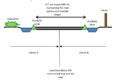
The ditch by my property runs alongside a road – is it the responsibility of Surrey County Council’s Highways Team to manage it?
The riparian owner of any ditches alongside roads is normally the adjoining landowner, as the highway boundary invariably lies along the top of the bank closest to the road. Adjacent owners should not carry out any work on the ditch which would restrict road surface water draining into it. Although the County Council and Highways Agency in their role as the Highway Authority has the right to discharge rainwater from the
highway into these ditches, the
landowner is responsible for
maintaining it.
What about if a stream runs underneath my property?
If a watercourse runs underneath your property or land in a culvert or pipe it is still your responsibility to keep it clear of debris and running freely. Underground culverted watercourses are more likely to occur in urban areas where historic development has taken place. It is important that you carry out regular maintenance, as if a culvert blocks it can causing flooding upstream for which you may be liable. There are many drainage companies that can inspect and clear culverts and offer you specialist advice on management.
If a culvert runs along the boundary of two landowner's land, they are jointly responsible for the culvert. Surrey County Council may be able to tell you if you have an underground watercourse on your land.
Can I just fill in the ditch if it is on my property?
No. These watercourses generally fulfil an important role in preventing local flooding. Plans for any works on ordinary watercourses, other than general cleaning and routine maintenance such as the removal of weeds or debris, must be approved by Surrey County Council. Consent for the work must be secured before starting. This applies to any changes which might affect the flow or capacity and include installation of dams, weirs, mills, channel diversions and in particular, culverting or piping.
How do I maintain the watercourse?
We have produced a guide called “Good Practice for Watercourse Maintenance” which tells you in detail all you need to know, but in summary maintenance should include; keeping vegetation under control (especially preventing large trees from blocking the watercourse), removing any obstructions to the flow of watercourse such as grass cuttings, litter and other debris and regularly removing silt to prevent it blocking the ditch, channel or pipe.
Other things to think about are:
Your own health and safety; working near water can be dangerous.
The watercourse may contain invasive species or protected wildlife which may require particular maintenance techniques or specialist advice.
Consent from the Environment Agency or the County Council may be required for any works other than general cleaning and routine maintenance, such as any change to the size or shape of the watercourse.
More information on these aspects is contained within the good practice guide.
What about the vegetation and wildlife in the watercourse?
Ditches can form very important habitats and may contain important species of flora and fauna that are protected or invasive species which are controlled under the Wildlife and Countryside Act 1981. The ‘Good Practice for Watercourse Maintenance’ document contains lots more information and links to advice.
Why is all this important?
Watercourses are designed to drain surface water away, this helps prevent flooding that puts property, roads, land and infrastructure at risk. If the system of ditches and culverts are maintained to a good standard, any flooding is likely to only affect areas in the floodplain. Not all watercourses transport water, as some act as storage areas, but maintenance of these is important too, as they prevent water collecting elsewhere.
The cost of maintaining a watercourse is minor compared to the cost from flood damage, not to mention the distress and inconvenience caused.
The above information can be downloaded as a PDF here
Where can I find out more?
Find out more about riparian ownership on GOV.UK.
https://www.gov.uk/government/publications/riverside-ownership-rights-and-responsibilities
You can contact the Parish Council for more local information too. Ideally send an email tp our clerk with your contact details and detailed query in the first instance.
Advice from Guildford Borough Council
For residents to report a dead animal in a residential road, please either complete the following form Dead animal - Dead animals - Guildford Borough Council- the form states litter, but in the box which asks for further details, please state that this is actually to report a dead animal.
Alternatively, email us here at Customer Services, via customerservices@guildford.gov.uk or by calling 01483 50 50 50 to report the issue.
With regards to Trunk Road cleaning, such as the A3 or A31, please be advised that this is a large scale operation that can only be done at specific times. These are published on our website. I have provided a link for you;
Trunk road cleaning - Clearing litter - Guildford Borough Council
If the animal is large and is posing a hazard to road users, it should be reported to Surrey County Council via 0300 200 1003 for an emergency response.
If you would like to be informed of important information relating to Seale & Sands, please complete the form on our contact page.
BT Openreach are currently working on Blighton Lane to restore service to some 250 homes locally. As a result Blighton Lane has been closed from its junction with Seale Lane to just before Furze Hill. The section from Furze Hill to Sands Road is open. The plan is that the closed section will re-open at 1530 today (Weds 16th) and close again tomorrow between 0930 and 1530 and maybe the same again on Friday for the work to continue. Given the number of (and vulnerability of some) affected customers, there is a chance that the closure may remain in place overnight to allow temporary cable laying.
We believe the problem has been caused as a result of tree roots and water ingress to the cabling ducts which has damaged the cables.
We would like to take this opportunity to give our thanks to Sheelagh Hoyland, who has, without fail monitored the wellbeing of our defibrillator in The Sands since we installed it back in 2015. Sheelagh and her husband David are moving from the village and we wish them well in their new home.
We need your help. If you are willing to take over the role, which involves making a visual check on the defibrillator’s indicators every fortnight and reporting to us via email or text (it’s not difficult or onerous), please let us know. Monitoring is an important task that ensures this vital piece of equipment is ready for the community to use when required.
Today we are pleased to launch our new web-site! Hope you enjoy reading it.
A cycle race, similar to previous but with a different route, will run through the villages between 13:30-15:45. The route is 3.8miles long and the race distance is 55miles, so the race will run for 14 laps.
This race is organised by VCMeudon bike racing club: https://www.vcmeudon.com/contact
You can see the race route here: https://www.surreyleague.co.uk/event-directory/
(The route shown on the Surrey League site shows the race hq as Seale Pavilion, however this is incorrect as the PC has nothing to do with this race.)
Further to the the new signage installed in August we, along with 2 residents of The Sands have negotiated a further 2 signs to be replaced, of a retro reflective type, to be installed on Elstead Road on the approach to Littleworth Cross. The signs have been paid for by the residents and the work should take place between Jan-March 2019 if not before. SCC were unwilling to undertake any further works here as they feel the signage, both above ground and on the road is within legislation guidelines and therefore adequate.
We have also ensured that SCC will cut back the foliage that is partially hiding the ‘Crossroad Ahead’ sign approaching the junction from the west on Littleworth Road. We anticipate the vegetation cut back will be undertaken before the end of September.
We would urge all residents to take care when using the crossroads. Please inform the PC of any new incidents at this junction as we will monitor and pass on to SCC and the Police.
The PC agreed with SCC back in February this year that they would install a new retro reflective Give Way sign on the approach to Littleworth Cross on Seale Road. This is due to the continued concern over the number of incidents at this junction. The sign was installed in August.
Both our defibrillators are housed in locked cabinets in ex. BT telephone boxes, now signed as ‘DEFIBRILLATOR’ and are located as follows:
Smugglers Way (adjacent to the Barley Mow P.H. just off Sands Road) The Sands GU10 1NE
Manor Fields on Wood Lane at the crossroads with Seale Lane and Elstead Road GU10 1HR
Both defibrillators are owned and maintained by the PC. If you see any issues with the defibrillators or their housing, please inform the PC immediately.
Below is advice from the British Heart Foundation.
4 steps to take if someone is having a cardiac arrest
Cardiac arrests can happen to anyone, at any time. The following steps give someone the best chance of survival. If you come across someone in cardiac arrest:
Call 999
Ask someone to bring a defibrillator if there’s one nearby
Turn on the defibrillator and follow its instructions.
For more information, read this guide to defibrillators from the Resuscitation Council.
Who can use a defibrillator?
You don’t need to be trained to use a defibrillator – anyone can use it. There are clear instructions on how to attach the defibrillator pads. It then assesses the heart rhythm and will only instruct you to deliver a shock if it’s needed. You cannot deliver a shock accidentally, the defibrillator will only allow you to shock if it is needed.
In a recent survey, three quarters of people said they wouldn’t feel confident enough to act if they saw someone having a cardiac arrest. With more CPR training and greater awareness, we can change that.
Where can I find a defibrillator?
Defibrillators are normally located in workplaces and public spaces like airports, shopping centres, community centres, and train stations. These defibrillators are known as public access defibrillators (PADs) as anyone can use them.
If you need a defibrillator in an emergency, the 999 call handler will often know where one is and tell you, so you can ask someone to get it. By performing CPR and using a defibrillator, you’ll give someone the best possible chance of survival, but there isn’t always a defibrillator close enough to help save the life of someone having a cardiac arrest.
Why do we need more defibrillators?
To help someone who is in cardiac arrest effectively, a defibrillator needs to be found as quickly as possible. For every minute it takes for the defibrillator to reach someone and deliver a shock, their chances of survival reduce by up to 10%.